1 February-7 February 2012
New Activity/Unrest
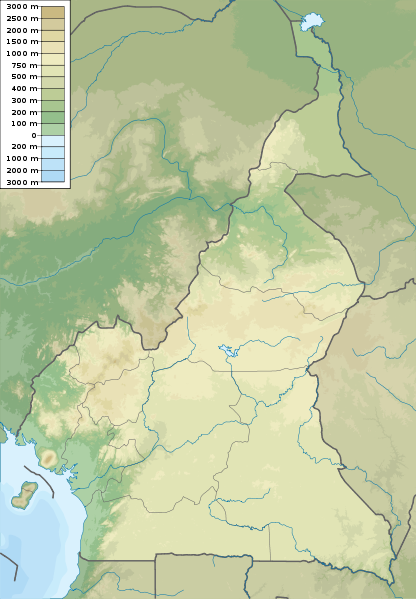
CAMEROON Cameroon 4.203°N, 9.170°E; summit elev. 4095 m
 A news article stated that explosions from Mount Cameroon were observed by tourists who were in the area on 3 February. The tourists reported hearing strong explosions followed by observations of “flames” and ash.
new article
Geologic Summary:

Mount Cameroon, one of Africa’s largest volcanoes, rises to 4095 m above the coast of west Cameroon. The massive steep-sided volcano of dominantly basaltic-to-trachybasaltic composition forms a volcanic horst constructed above a basement of Precambrian metamorphic rocks covered with Cretaceous to Quaternary sediments. More than 100 small cinder cones, often fissure-controlled parallel to the long axis of the massive 1400 cu km volcano, occur on the flanks and surrounding lowlands. A large satellitic peak, Etinde (also known as Little Cameroon), is located on the southern flank near the coast. Historical activity, the most frequent of west African volcanoes, was first observed in the 5th century BC by the Carthaginian navigator Hannon. During historical time, moderate explosive and effusive eruptions have occurred from both summit and flank vents. A 1922 SW-flank eruption produced a lava flow that reached the Atlantic coast, and a lava flow from a 1999 south-flank eruption stopped only 200 m from the sea.
CLEVELAND Chuginadak Island 52.825°N, 169.944°W; summit elev. 1730 m

AVO reported that during 2-7 February cloud cover over Cleveland prevented views of the lava dome in the summit crater. The Volcano Alert Level remained at Watch and the Aviation Color Code remained at Orange. No current seismic information was available because Cleveland does not have a real-time seismic network.
Geologic Summary.
 Symmetrical Mount Cleveland stratovolcano is situated at the western end of the uninhabited dumbbell-shaped Chuginadak Island in the east-central Aleutians. The 1,730-m-high stratovolcano is the highest of the Islands of Four Mountains group and is one of the most active in the Aleutians. Numerous large lava flows descend its flanks. It is possible that some 18th to 19th century eruptions attributed to Carlisle (a volcano located across the Carlisle Pass Strait to the NW) should be ascribed to Cleveland. In 1944 Cleveland produced the only known fatality from an Aleutian eruption. Recent eruptions from Mt. Cleveland have been characterized by short-lived explosive ash emissions, at times accompanied by lava fountaining and lava flows down the flanks.
KARKAR Northeast of New Guinea (SW Pacific) 4.649°S, 145.964°E; summit elev. 1839 m
 Based on analyses of satellite imagery, the Darwin VAAC reported that a possible ash plume from Karkar rose to altitudes of 7.6-10.7 km (25,000-35,000 ft) a.s.l. and drifted NE and E on 1 February.
Geologic Summary.
 Karkar is a 19 x 25 km wide, forest-covered island that is truncated by two nested summit calderas. The 5.5-km-wide outer caldera was formed during one or more eruptions, the last of which occurred 9000 years ago. The eccentric 3.2-km-wide inner caldera was formed sometime between 1500 and 800 years ago. Parasitic cones are present on the northern and southern flanks of basaltic-to-andesitic Karkar volcano; a linear array of small cones extends from the northern rim of the outer caldera nearly to the coast. Most historical eruptions, which date back to 1643, have originated from Bagiai cone, a pyroclastic cone constructed within the steep-walled, 300-m-deep inner caldera. The floor of the caldera is covered by young, mostly unvegetated andesitic lava flows.
PAPANDAYAN Western Java (Indonesia) 7.32°S, 107.73°E; summit elev. 2665 m
 CVGHM lowered the Alert Level for Papandayan from 3 to 2 (on a scale of 1-4) on 31 January. No eruption details or reasons for the change were given in the report.
Geologic Summary.
 Papandayan is a complex stratovolcano with four large summit craters, the youngest of which was breached to the NE by collapse during a brief eruption in 1772 and contains active fumarole fields. The broad 1.1-km-wide, flat-floored Alun-Alun crater truncates the summit of Papandayan, and Gunung Puntang to the N gives the volcano a twin-peaked appearance. Several episodes of collapse have given the volcano an irregular profile and produced debris avalanches that have impacted lowland areas beyond the volcano. Since its first historical eruption in 1772, in which a catastrophic debris avalanche destroyed 40 villages, only two small phreatic eruptions have occurred from vents in the NE-flank fumarole field, Kawah Mas.
SEMERU Eastern Java (Indonesia) 8.108°S, 112.92°E; summit elev. 3676 m

On 3 February, CVGHM reported that from 29 December 2011 to 2 February 2012 seismicity increased at Semeru, and dense white and gray plumes rose as high as 600 m above the Jonggring Seloko crater. During the month of January crater incandescence was observed and avalanches carried incandescent material 200-400 m away from the crater. On 2 February a large explosion was reported and incandescent material was ejected 2.5 km from the crater. Based on the seismic activity and visual observations, CVGHM raised the Alert Level from 2 to 3 (on a scale of 1-4) on 2 February.
Geologic Summary.
 Semeru is the highest volcano on Java and one of its most active. The symmetrical stratovolcano rises abruptly to 3,676 m above coastal plains to the S and lies at the southern end of a volcanic massif extending N to the Tengger caldera. Semeru has been in almost continuous eruption since 1967. Frequent small-to-moderate Vulcanian eruptions have accompanied intermittent lava dome extrusion, and periodic pyroclastic flows and lahars have damaged villages below the volcano. A major secondary lahar on 14 May 1981 caused more than 250 deaths and damaged 16 villages.
TUNGURAHUA Ecuador 1.467°S, 78.442°W; summit elev. 5023 m

IG reported a new episode of activity from Tungurahua on 4 February with an explosion that produced roaring heard 14 km NW in Palitahua and Guadalupe. On 4 February an ash plume rose to altitudes of 7-8 km above the crater and drifted NE; lapilli fall was reported in Baños (9 km N), Pillate (7 km W), and Juive (7 km NNW). IG staff aboard a commercial flight on 4 February observed an ash plume that rose to an altitude of 1 km above the crater and drifted W. Ashfall and roaring noises were reported in Baños, Pillate, Juive, Pondoa (8 km N), Pelileo ( about 7 km NW), Guadalupe, Cevallos (23 km NW), and Patate (NW). A pyroclastic flow descended into the Achupashal drainage (NW). At night incandescent blocks ejected by an explosion traveled 1 km down the flanks. On 5 February clouds prevented views of the volcano, though loud “cannon shots” were heard in Baños and Juive, and ashfall was reported in Manzano (8 km SW). Clouds prevented views of the volcano during 6-7 February.
Geologic Summary.

The steep-sided Tungurahua stratovolcano towers more than 3 km above its northern base. It sits ~140 km S of Quito, Ecuador’s capital city, and is one of Ecuador’s most active volcanoes. Historical eruptions have all originated from the summit crater. They have been accompanied by strong explosions and sometimes by pyroclastic flows and lava flows that reached populated areas at the volcano’s base. The last major eruption took place from 1916 to 1918, although minor activity continued until 1925. The latest eruption began in October 1999 and prompted temporary evacuation of the town of Baños on the N side of the volcano.
|
Dukono, Halmahera |
Etna, Sicily (Italy) |
Fuego, Guatemala |
Hierro, Canary Islands (Spain) |
Karymsky, Eastern Kamchatka (Russia) |
Kilauea, Hawaii (USA) |
Kizimen, Eastern Kamchatka (Russia) |
Popocatépetl, México |
Puyehue-Cordón Caulle, Central Chile |
Sakura-jima, Kyushu |
Santa María, Guatemala |
Shiveluch, Central Kamchatka (Russia) |
Soufrière Hills, Montserrat |
Suwanose-jima, Ryukyu Islands (Japan)