Helping humankind live with the earth not against it

Author: katborealis (Page 14 of 28)

Technical Difficulties

I am in the process of changing feed hosts. And my old host is not making it easy. To top it off they have interrupted my service. I am working on getting it back at least minimally so I can send out a note to all my itunes subscribers once I confirm the new feed is up and working.

So hang in there!

I am going to be re-listed as Borealis Meditation Podcast

It is submitted to itunes and should be going through soon!

Thank you all for being awesome! 🙂

Much love!

~Kathleen

San Fran here I come! PPSM3

Yes I will be there! I am going to be attending the Pagan Podkin Super Moot #3 in San Francisco!

One of my favorite cities to visit! Trolley Cars, the Golden Gate Bridge, China Town, Fisherman’s Warf.. So many fun things to do! And of course meeting wonderful listeners and my amazing podkin!

So hope to see you there!

Earthquakes 8/5 – 8/11

Earthquakes from 8/5 – time of publishing (8:15 PM on 8/11) from Magnitude 3 and up. Past week are yellow and earthquakes from yesterday are orange, and the last hour are in red.

Totals for the last week:
M2.5 + 226
M5 + 27
M6 + 3 (Largest being the M 6.4 23km SW of Ahar, Iran 2012-08-11 12:23:17)
M7 + 0

Some Earthquakes in the news:

Deadly Quakes Strike in Iran (See largest listed above)
3.4 earthquake strikes near Palos Verdes Point  (updated to M 3.5 17km WSW of Manhattan Beach, California 2012-08-11 15:33:03)

DID YOU FEEL ANY EQs THIS WEEK!? Make sure when you do you head on over to the USGS earthquakes page and fill out a “did you feel it?” report!

Curiosity notes and information, because… MARS

Here is an illustrated guide to the information I presented in the last mini-episode. Because sometimes pictures help! I am overflowing with joy about this mission! In fact any mission to expand our understating of the universe fills me with pride for our species and joy! 
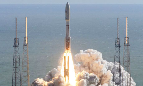
The Mars Science Laboratory (the mission name) carrying the rover Curiosity has landed on Mars! But lets back up. The Mars Science Laboratory was launched from Cape Canaveral Air Force Station aboard an Atlas V rocket around 10:02 EST on November 26th, 2011. 
The end to the transit came with the successful  landing of the rover Curiosity in Gale Crater. The official landing time is 05:14:39 UTC on August 6. However, it takes 14 minutes for a message from Mars to reach earth so it was more like 05:30 when landing was confirmed. A orbiting satellite named Mars Reconnaissance Orbiter took a photo of Curiosity descending by parachute. And Odyssey another satellite acted as a go between redirecting communications back to earth since the landing site was beyond the horizon.  
The Curiosity Rover is 5 times as massive as Spirit and Opportunity two rovers currently on Mars. 
And has over 10 times the mass of scientific instruments 
It landed in the Aeolis Palus region of Gale Crater near the mountina Aeolis Mons a.k.a. Mount Sharp
Looks like everything survived the landing and the estimated life is “4 years or until the parts die” 
MSL is part of a longer term NASA Mars Exploration Program 
Curiosity was named in an essay contest won by 6th grader Clara Ma from Kansas 

Objectives: from the source! (This was take from the NASA mission website) 

Mars Science Laboratory: Mission Objectives

To contribute to the four science goals and meet its specific goal of determining Mars’ habitability, Mars Science Laboratory has the following science objectives.

Biological objectives:
1. Determine the nature and inventory of organic carbon compounds
2. Inventory the chemical building blocks of life (carbon, hydrogen, nitrogen, oxygen, phosphorous, and sulfur)
3. Identify features that may represent the effects of biological processes

Geological and geochemical objectives:
4. Investigate the chemical, isotopic, and mineralogical composition of the martian surface and near-surface geological materials
5. Interpret the processes that have formed and modified rocks and soils 

Planetary process objectives: 
6. Assess long-timescale (i.e., 4-billion-year) atmospheric evolution processes
7. Determine present state, distribution, and cycling of water and carbon dioxide

Surface radiation objective:
8. Characterize the broad spectrum of surface radition, including galactic cosmic radiation, solar proton events, and secondary neutrons

The landing and study area: Gale Crater

This is a topographic map of Gale Crater. The circle is the landing site.

Gale Crater Stats!

  • The location: Gale Crater is 5.4°S 137.8°E. 
  • It is 154 km (96 mi) in diameter and believed to be about 3.5 to 3.8 billion years old. 
  • The crater was named after Walter Frederick Gale, an amateur astronomer from Sydney, New South Wales, Australia, who observed Mars in the late 19th century. 
  •  Mt Sharp is 5.5 km or 18,000 ft high 

Why is Mt Sharp officially known as Aeolis Mons so interesting?

It appears to be composed of a layered material that may have been deposited over 2 bilion years Origin is not certain but the current hypothesis is that it is an erosional feature and is the remnants of sedimentary layers that once filled the crater completely and maybe just maybe were originally deposited in a lakebed like environment. Oh course this idea is debated as there is possible evidence of cross bedding in the upper strata which suggests an Aeolian or wind driven deposition process.

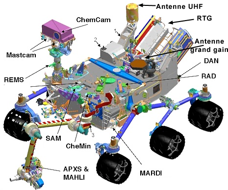
The toys… I mean scientific instrumentation on Curiosity

Where all of these instruments are located on the rover

Mast Camera (Mast Cam) – this is the large camera that will soon be sending us awesome high res photos of mars! There are two cameras and can take multispectral and true color images

Mars Hand Lens Imager (MAHLI) this camera is used to take microscopic images of rock and soil

First MAHLI image
Mars Descent Imager (MARDI) took photos during the descent with a 1.3 milli-sec exposure time 
[youtube http://www.youtube.com/watch?v=UcGMDXy-Y1I]
This is that video taken by MARDI
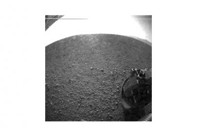
Hazards Avoidance Cameras (HazCams) two pairs of black and white navigation cameras on the four corners of the rover. They are for autonomously avoiding hazards and for safe position of the arm on rocks and soils. This is what sent the first images back.
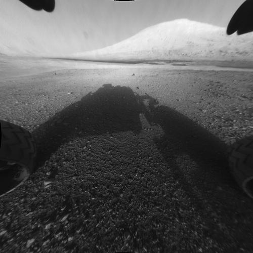
First image sent back by Curiosity via Odyssey (remember that other satellite???) 
This is image #2 and the last one sent before Odyssey also went out of range
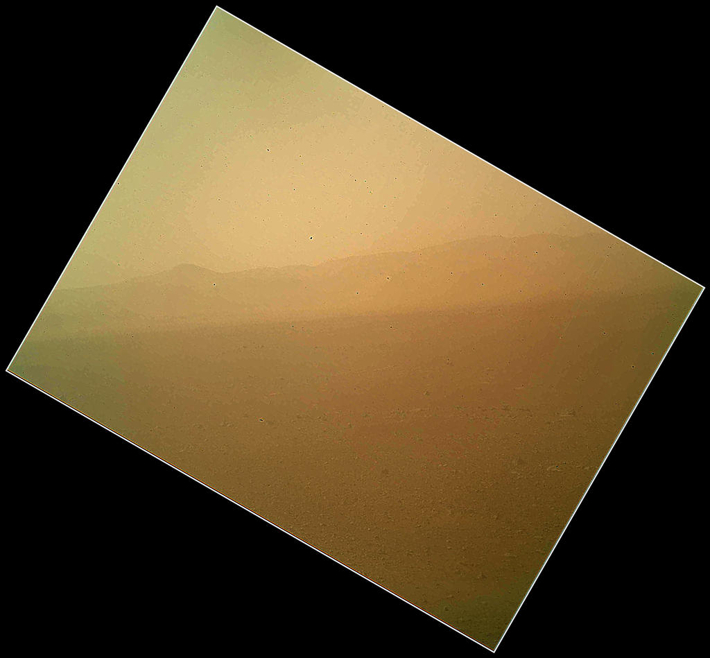
Navigation cameras (NavCams) black and white cameras on the mast for navigation
First NavCam image! Look its Mt Sharp! 
Chemistry and Camera Complex (ChemCam) a suite of remote sensing instruments including the first laser induced breakdown spectroscope system to be used for planetary science and a remote micro image. It can target a rock or soil sample from up to 7m away, vaporize it with a laser and collect a spectrum of light emitted by the vaporized rock. This will be used to do chemical analysis.
Rover Environmental monitory station (REMS) measured the environment so humidity pressure temperature  wind speed and ultra violet radiation 
Alpha particle x-ray spectrometer (APXS) irradiates a sample with alpha particles and maps the spectra of xrays that are re-emitted to determine the elemental composition of the samples. 
Chemistry and Mineralology (CheMin) x-ray diffraction and x-ray fluorescence instruments. These can ID and quantify the abundance of the different minerals that they find on Mars. It has a drill and will drill samples into the rocks and the resulting fine powder will be sampled. The xrays are diffracted back by the crystal structure and these characteristic patterns allow for ID of the minerals! 
Radiation Assessment Detector (RAD) this was the first of ten MSL instruments to be turn on and characterizes a broad range spectrum of radiation in the environment within the spacecraft the goal is to research the shielding needed for human explorers 
Dynamic Albedo of Neutrons (DAN) a pulsed neutron source and detector for measuring hydrogen or ice and water at or near the surface 
Sample Analysis at Mars (SAM) analyses organics and gasses from atmosphere and soils. 

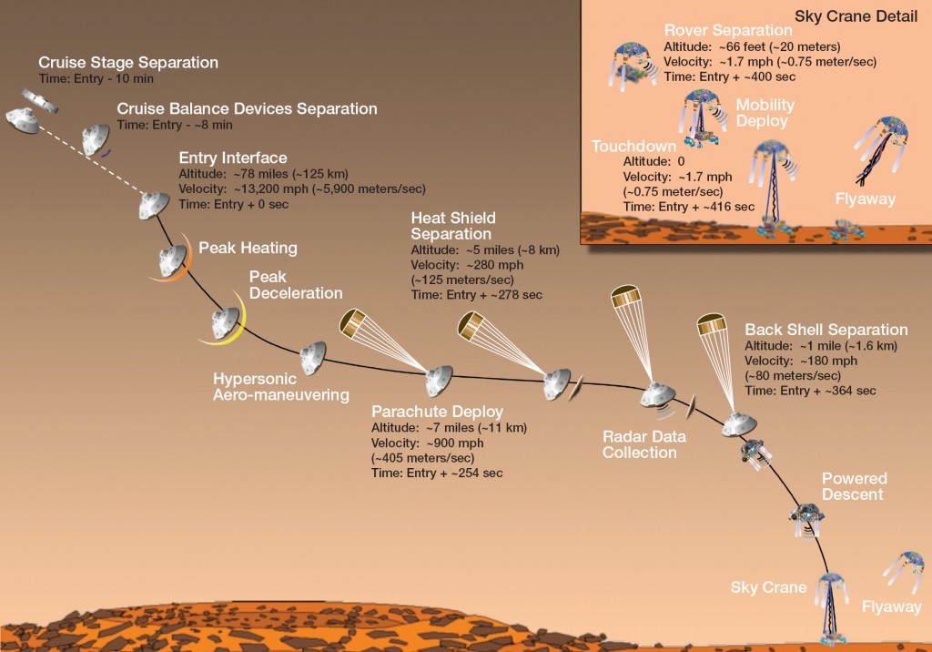
Entry, Descent and Landing: EDL
As you can see the landing of Curiosity was a highly choreographer dance. 
First Curiosity had to say goodbye to the cruise stage that got it all the way to Mars.
Second it hit the upper atmosphere heating up on entry. However there isn’t enough of atmosphere to slow it down enough
So… Third the parachute was deployed to slow it down
Fourth the heat shield separates falling away allowing the instrument to get a radar lock on the ground
Fifth the back shell with the parachute separates because that didn’t slow it down enough
Sixth the SkyCane stage fires jets to slow itself further and lower itself into position
Seventh the rover is lowered on cables by the sky cane,
That done… the sky cane flies away to crash away from the science targets. 
Curiosity is now safely on the Martian surface and can wake up, check her surroundings and start getting ready for some science! 
Here are the locations of the various parts. 

Again if you have any further questions feel free to ask! Or keeping reading and exploring!

Tons of information (and all of this information) can be found on…
The Mission Website 
Wikipedia
Reddit’s AskScience official Curiosity thread 

Also you can follow Curiosity on Twitter!

Earthquakes 7/28 – 8/03

Earthquakes from 7/28 – time of publishing (8:00 PM on 8/03) from Magnitude 3 and up. Past week are yellow and earthquakes from yesterday are orange, and the last hour are in red.

Totals for the last week: 
M2.5 + 240
M5 + 24
M6 + 4 (Largest was on 07-28-12 at 20:03:56 UTC and was a M 6.5 Papua-New Guinea Region )
M7 + 0

Some Earthquakes in the news: 
Peru Earthquake Measures 6.1 Magnitude ( M6.1 34km E of Pucallpa, Peru 2012-08-02 09:38:31 UTC)
Minor Earthquake Rattles Virginia Area Again ( M2.4 16km ESE of Lousia, Virginia 2012-07-31 04:43:02 UTC)

DID YOU FEEL ANY EQs THIS WEEK!? Make sure when you do you head on over to the USGS earthquakes page and fill out a “did you feel it?” report!

Pagan Volcano Activity 25 July-31 July 2012

Pagan Volcano made it into the activity report again!
So let’s see what our volcano is up to!

Global Volcanism Program: USGS Weekly Volcanic Activity Report:
Pagan Volcano:
Minor steam-and-gas plumes from Pagan were observed in satellite images during clear periods from 20 to 27 July. The Aviation Color Code remained at Yellow and the Volcano Alert Level remained at Advisory.


Alright let’s go through this one and talk about what it means. This is some low level activity. “minor steam and gas plumes” this is generally due to degassing of the volcano. Magma has a lot of dissolved gases in it and as it rises to the surface those gases come out of solution and make bubbles and try to escape. A volcano can sit and de-gas happily and release lots of pressure and never explode. 

So how are these detected in satellite images? Well if the degassing volcano is mostly degassing water it can be very hard. From what I understand two images are taken within different bands of light. So like a red and blue band for example (that is not what it is I actually don’t know it was just an example ok!?) These images are differenced and the result can tell you if a “cloud” feature is mostly water (like weather clouds) or has other things in it (not weather cloud). It also says that these images were taken when it was clear, so it might just be visible spectrum and you can see a plume coming off of the volcano.

Ok now for a picture!

Here is a small plume from Pagan. Note the color. In general ash rich plumes (eruptions) are more gray. This is most likely degassing and lots of water vapor! 

Hope you enjoyed that look at Pagan Island!
~Kat

Happy Llamas!

I know its Lammas, but every damn year when I see the word “Lammas” I think llamas. So therefore on my calendar I am renaming it llamas. Along with what I am doing already (yoga on the beach, little fire and some damn good bread we made last night) I am going to post llamas. Because, well… why not!? (Also the reason to do anything in science…. “Why do you want to drill a hole through an active volcano? WHY NOT!? WE CAN!!” <– and Japan did.)

LLAMAS!

Llama with necklace and lovely earnings… I decided that these are for telling which llama belongs to who or some llamas are Fashionistas. 

Earthquakes 7/21 – 7/27

Earthquakes from 7/21 – time of publishing (8:15 PM on 7/27) from Magnitude 3 and up. Past week are yellow and earthquakes from yesterday are orange, and the last hour are in red.

Totals for the last week:
M2.5 + 193
M5 + 23
M6 + 3 (Largest was on 07-26-12 at 5:33:31 UTC and was a M 6.7 in Mauritius – Reunion Region)
M7 + 0

Some Earthquakes in the news:
6.5-magnitude earthquake destroys houses in the Solomon Islands (M6.5 39km SW of Honiara, Solomon Islands 2012-07-25 11:20:27)
No damage or injuries after 2 earthquakes rattle NorCal coast (M5.2 83km W of Ferndale, California 2012-07-21 06:04:21 / M5.1 105km W of Ferndale, California 2012-07-21 01:52:01)
Small earthquakes rattle NJ town (M1.1 1km NW of Dover, New Jersey 2012-07-17 02:25:45)
6.7-magnitude earthquake strikes the Indian Ocean off Mauritius (M6.7 Mauritius – Reunion region 2012-07-26 05:33:31)
Indonesia shaken by powerful earthquake; no tsunami triggered (M6.4 34km NW of Sinabang, Indonesia 2012-07-25 00:27:45)
LA Earthquake: 3.8 Magnitude Quake Shakes Marina Del Rey Area Early Wednesday Morning, July 25 (M3.7 2km ESE of Marina del Rey, California 2012-07-25 10:18:41)

DID YOU FEEL ANY EQs THIS WEEK!? Make sure when you do you head on over to the USGS earthquakes page and fill out a “did you feel it?” report!

Pagan Island, getting to know you….

There was no activity reported for Pagan Volcano this week, so we are going to look at the island itself this week. I think Its an excellent example of an island arc volcano. 
This is a diagram of an island volcanic arc. See? We are back to the structure of the earth, like I said its always important. In order to produce an island volcanic arc, you will have an oceanic/oceanic subduction zone. The oceanic crust that is subducted is the older thicker and denser of the two oceanic plates. 
Once the older oceanic crust is subducted to around 100km the water will be driven out of the rocks and lower the melting temperature of the surrounding mantle. That is the 101 explanation of what is going on and is pretty accurate. This produces melt that becomes buoyant and rises. When this magma breaks through to the ocean floor it starts to build volcanoes. 
Once these volcanoes start to build they produce underwater eruptions until they have built up enough mass to break the ocean surface. Then it starts to build islands. These islands are volcanic arcs. 
That is how Pagan Volcano was built. 

As you can see Pagan Island is part of a chain of volcanic arc islands that sit above the subducting Pacific plate as it dives under the Philippine Sea Plate. The Mariana trench is also home to the deepest point on the earth the Challenger Deep. It is 10,898 m (35,755 ft) to 10,916 m (35,814 ft) below sea level. 
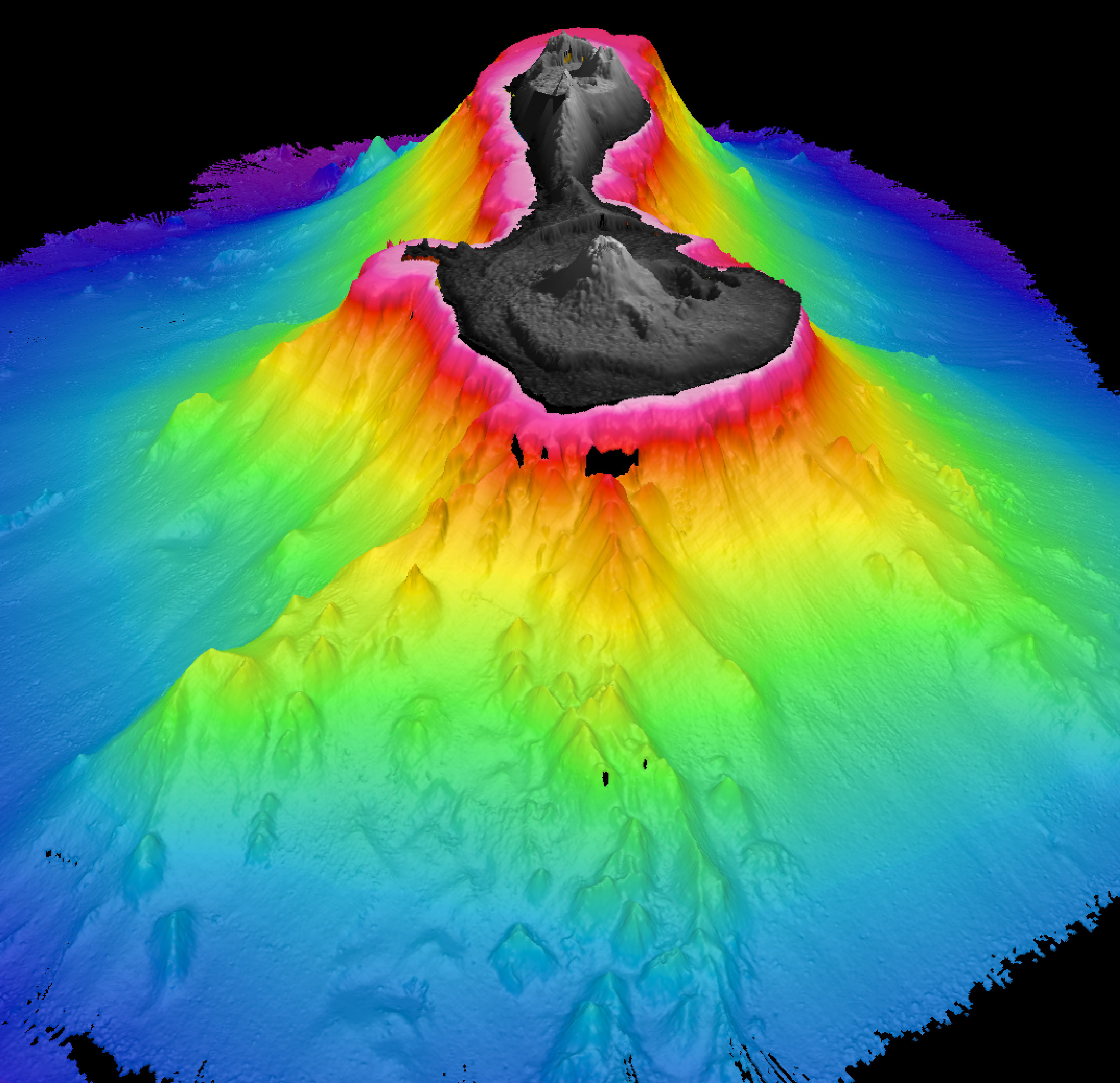
Here is Pagan Island rising from the seafloor with a vertical exaggeration of 3
Next time we will talk about the island itself and how it formed! 

References, more reading and image sources
http://blue.utb.edu/paullgj/physci1417/Lectures/Plate_Tectonics.html
http://www.sciencedirect.com/science/article/pii/S0012821X08005529
http://www.soest.hawaii.edu/pibhmc/pibhmc_cnmi.htm
Pagan Island Wikipedia page
Mariana Trench Wikipedia page
Volcanic Arc Wikipedia page 

« Older posts Newer posts »

© 2026 Kathleen Borealis

Theme by Anders NorenUp ↑